Sunday, September 22, 2019

Big Horn Mine

I have been quite few times on Mount Baden-Powell, but never realized there is an old mine just few miles from trail head. Mines maybe new area of exploration for me, I read few books about mining in California and my son was even more excited after playing Minecraft. Tunnels going deep into the mountain for more than 1 mile and good map would definitely help not to get lost. We went probably half mile deep and should get back to explore more next time. We also hiked ridge directly to Baden-Powell, which was quite doable.
Mine to Baden-Powell loop map
Big Horn Mine from the trail


Mine Entrance

Mining steam engine


Sunday, July 28, 2019

Split Mountain hike

Split Mountain 14,064 ft another beautiful 14er I did this year. The hardest part was to get to trail head. One option was to go via Glacier Lodge Rd from Big Pine and than 12 miles on unpaved road going south. Well, If I could not make it on Prius I would have to hike for up to 12 miles, not good at all. Second options was going via Tinnemaha Campground, up to 4 miles of additional hiking, not bad. The problem arise when google suggested to go through private property land and I decided to hike around from the south side, which involved crossing creek (and swamp) twice. DON'T GO THIS WAY! On the way back I found correct road (on the north side), which does not even involve private land crossing, but 4x4 is definitely required.
Hike itself is quite easy and enjoyable , short section of class 2/3 after you pass Red Lake and get to the ridge, but before you reach main crest is not too bad. I can recommend this as first 14er.


Red Lake

Sunday, July 21, 2019

Thousand Islands Lake, 3 days backpacking

My sister was visiting and we want to spend 2-3 days in back country. Last time, few years ago, we did a loop via Minarets and Ediza lake and this time I want to check out Thousand Islands Lake. We also attempted to climb Banner Peak, but that was too much for my sister and we turned around quarter mile short from Ritter/Banning saddle.
Banner Peak

Thousand Islands Lake


Going through class 3 terrain

Lake Catherine

Our campsite

Sunset over Thousand Islands Lake

Agnew Meadows

Sunday, July 14, 2019

US Paragliding Nationals, Chelan 2019

Not much flying for me last 2 years, so my goal was to get out and flew as much as I can and competitions, especially Chelan is perfect for this. I stopped and flew Herd Peak near Shasta Mt. on my way there.
Herd Peak
We had 5 tasks out of 7 days, 124 pilots participated, overall I took 76th place. Results are here. I made goal twice in the first and last tasks, not great for the score, but overall I was satisfied with ~25 hours of airtime. Competition level was definitely higher than last time I flew in Chelan, more pilots was making goal and faster too. In the Sport class 12 pilots had better results than me on the D wing.
Russian team

Chelan launch

Start

Chelan lake

Crossing river

Over the launch


LZ

Thursday, July 4, 2019

Mount Shasta hike

Another long standing goal for me Mount Shasta 14,179 feet was finally tagged this year. On my way to US Paragliding Nationals in Chelan I added few days to hike. After climbing Russell, Whitney and Williamson just last month, I don't need any acclimatization and did it as day hike via Avalanche Gulch. Standing on the top I was little bit disappointed, compared to any Sierra peak there was not much to see besides endless green land and clouds below.
Mount Shasta


Mount Shasta register


Lake Helen


Sunday, June 30, 2019

Mt Williamson via North Fork of Bairs Creek hike

Mt Williamson 14,380 feet is the second highest mountain in both the Sierra Nevada range and the state of California. It's much harder than Whitney and have been on my to do list for quite some time. The standard ascent route is from the west side via Shepherd's Pass, involving 10,500 ft of elevation gain and 27 miles round trip. With top of the mountain still covered in snow we opted for direct and shorter route via North Fork of Bairs Creek, only 10 miles round trip, but there was no established trail in this area. Unfortunately, our car could not make it to trail head, crossing creek with deep swift water did not look very promising, which added another 2 miles each way.

First glimpse of the route


Bairs Creek

Waterfalls

Creek crossing
We camped at 10,000 ft just below the snow line. There was no good camping spots at that altitude and we have to flatten and move rocks around to make some.

 Grand Cirque

Flying off

Mt. Williamson register

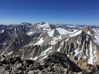
Looking north

Mt Tyndall