Bir Billing is a small village surrounded by big mountains famous for paragliding in Himachal Pradesh state of India. The best time to visit is either fall October - November or spring in April. Fall is more popular because of milder and more consistent weather.
Getting there. It's a long way to get there from US, it took me 42 hours door to door. You can fly west through China or Japane or east through UK, UAE or Germany, but in any case it's around 20-24 hours to get to New Delhi. From Delhi you have few options. Most convenient and most expensive is taxi, which cost $120-$150 depending on car size and it will take around 12 hours. You can order through hotel in Bir where you plan to stay. Bus is only $20 departing from Kashmiri Gate and time is similar to taxi.
Visa. Most nations including US and Russian citizens need to apply for visa. You can apply for regular visa $100 and it's good for 10 years or e-Tourist Visa $60 single entry up to 30 days only, stamped on arrival.
Sangrai Guesthouse
Accommodations. I was staying Sangrai Guesthouse, neat hotel 2 km from main landing field. There are a dozen other places where you can stay with very affordable prices $5-$15. You can make reservation via email or phone, some even provide Wi-Fi, but in my case it was available during 3 days out of 12. Since most of the places are in Tibetan Colony Protected/Restricted Area Permit also required. This year was different because of PWC, permits was available in Bir, but normally you have to go to Dharamsala to get it.
Food. My favorite places was Garden Cafe for breakfast, Nyingma Kitchen for dinner. Hotel Surya also serves excellent food, but it's slightly more expensive and crowded. Typical meal cost is around $3-$5. Make sure you try Ginger Lemon Honey tea and Masala chai. Because in the religion of Hinduism, cow is thought to be sacred animal there is no beef food, but you can order mutton or chicken. I also recommend to try Momo (dumplings) and Thukpa (soup) delicious Tibetan food. Expect 30-40 minutes delays if place is crowded.
Bir launch
Flying regulations. On the way to launch there is a block station and a person check and issue flying permits. It cost $8 per week and you will need to provide copy of passport's main page, copy of Indian visa, 2 pictures and copy of your national flight license. As long as you pay money you can get through and bring missing documents later. You also sign a waiver stating that you are not going to fly into big mountains.
Flying main range in Bir, India
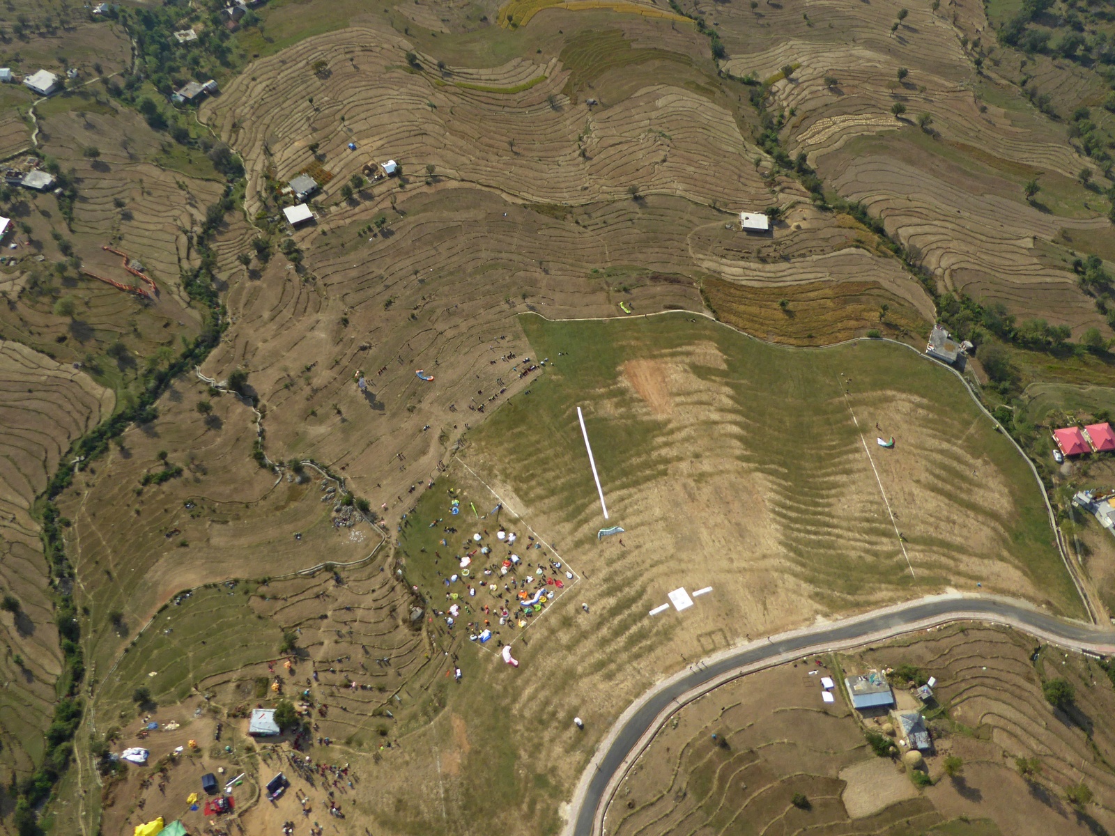
Flying main range. On the good days you can launch as early as 10:00 am. Typical flight is 60 miles Flight to Dharamsala and back. Overdevelopment is common and cloud base getting lower during the day. Conditions are relatively mild compared to South California and especially Sierra Nevada and Owens valley. In terms of skills you should be at least P3 to fly comfortably. Most of the time launch is in no wind conditions. Main landing is huge, but it's on the slight down slope, so overshoots and stalls close to the ground are common here among unprepared pilots. I recommend to walk LZ before your first flight. If you fly to Dharamsala and not make it back landings become very difficult with lots of power lines running in all possible directions. There is also a military base near Palampur. I recommend to upload a list of good LZs into your GPS and rely on them. Another good and common flight is to Mandi, opposite direction from Dharamsala. It's more technical because of lowering terrain, but usually this area stays clear from overdelopment later in the day.
Main Bir LZ
Flying back range. Big mountains are inviting, but don't underestimate your skills and risks involved. The deeper you fly the less people and roads you encounter with prospect of hike out can take several days or in case of serious injury your chances to survive are slim. Even if you push "SOS" button on your SPOT or lucky to have cell phone reception no one is going to come and rescue you, there is no such service in India, you can only rely on yourself and your good friends. Our group was fully prepared with bivi gear, water and food for couple days, tree recuse gear, first aid kit and most importantly we had support team in Bir. Both SPOT and DeLorme satellite trackers works fine, but unfortunately they are illegal in India. Worst thing you can do is to call from satellite phone another phone with Indian sim card, police will show up sooner than you think. Now back to the flying. From the start you cross first valley to the north and climb up using a ridges to 14K peaks. Typical wind aloft is from north east (head wind), and wind strength is very important. If it's more than 5 miles per hour on 14K you don't want to continue and can just glide out south back to main ridge. If wind is light you cross next valley to the east and continue to the lake. From here you can keep flying east toward Manali or turn south and exit to the main ridge. Later flight called "Big Loop", which is 25 miles FAI triangle. I did this flight 3 times with highest cloud base been 16K and lowest 12.5K.
Big Loop 1, looking east
Big Loop 2, looking east
Flight to Prashar Lake. I had the best flight of the trip on my last flying day in Bir. We started from "Big Loop" flight and then debated to continue to Manali or try to fly to Prashar Lake, located near Mandi. Flight to Manali would be more spectacular, crossing higher terrain, but 7 hours on the bus to get back was discouraging, so we choose Prashar. There is a distinctive mountain range going to the lake and there was a nice cloud street running above it, however with low cloud base it took me awhile to establish on the range.
Under the clouds
Ridge toward Prashar Lake
We was probably 7 miles from the lake when one pilot in our group had a cravat very close to terrain and was forced to throw reserve. She landed 100 meters from the top of the ridge in the forest, unscratched. There was a good field for top landing lower and after considering our options second pilot landed to assist with hike out.
Crash spot
Escape route
It was long night for the 2, covering more than 15 miles and navigating via goat's trails. I could not join the party since I was leaving Bir next day and attempted to fly back. I tried to cross main ridge near Mandi, but there was a strong valley wind from Kullu valley down low and I almost landed. Defeated I scratched for half an hour drifting back north to the higher mountains and eventually topped out under the clouds. Clock was running fast, day and conditions fading and shade from enormous cloud on my course line become bigger. I had one more attempt to cross main ridge near the only paved road across it and I failed. All was going well until I got closer to the ridge with probably 200 meters to spare, but flying though the lee I lost all my spare altitude and now was facing a difficult landing in the small village. Good approach, few wingovers and I'm on the ground in one piece, happy to be alive. Whole village was there to greet me and watched how I packed my staff.
My LZ
Landing out in a small village
2 mans was enthusiastic to accompany me to paved road and also helped to carry my 50 pounds backpack. It took us 2 hours to get down to the canyon, cross small river and hiked back up to the road. 15 minutes later taxi stopped and after another 2 hours I was back in Bir buying my bus tickets. My flying buddies come back only in the middle of next day, we was very fortunate that no one get injured.
Camping at 360. It was a fun experience with 10+ pilots, tales around fire at night and waking up to see sunrise. The only challenge was to pack all camping gear and fly overloaded glider, I think I was at least 10 kg above max weight (105 kg total) and Mantra did not want to turn at all. Second time I managed to get less staff and at 102 kg it was much better.
360 camp site
Pilots
Sunset
Campfire
Safety. During my stay there were 120 PWC pilots and probably 200+ free flyers and there was few accidents pretty much every single day with one fatality after I get back home. So let me list few very important items that most of you know very well, but worth repeating over and over again.
Unknown pilot descending on Beamer near Bir main LZ
Launch. Bir had an excellent launch in my opinion, but still some pilots had issues. Practice no wind launch.
Flights. Mostly they are straightforward, but there was at least 2 mid air, few cloud suck. Make sure you have a compass, GPS can freeze or simply does not work in the clouds. Pay attention to cloud development and have a good margin for escape if it's going to OD.
Landings. Don't stall your glider if you overshoot. Land as far from houses and villages as possible, since there are a lot of power lines. Practice top landing and spot landing at home site, it will be very useful in India.
Carry tree rescue kit and practice how to use it. I think that at least basic mountaineering experience is mandatory for any serious XC pilot.
Warm waterproof clothes, water and food for 2 days is mandatory, if you land on the tree or in the mountains don't try to hike out during the night.