![]() |
| Reavis |
![]() |
| Gavin |
![]() |
| Reavis |
![]() |
| Gavin |
My annual Mt. Whitney winter excursion was in the February this year. I went solo again since everyone was busy. Typical itinerary is drive from LA starting at 2:00 PM, arriving at trail head around 6:00 PM, hike to Lower Boy scouts lake (10,340 ft), few hours of rest, boil water and start hiking at 2:00 AM, top out around 10:00 AM, hike back and drive back to LA. Speed can vary greatly depending on snow conditions and my physical shape.
![]() |
| Whitney trail head |
![]() |
| Cold bivy on the snow |
![]() |
| Frozen water |
![]() |
| Sunrise near Upper Boy scouts lake |
![]() |
| First glimpse of Whitney |
![]() |
| Sun |
![]() |
| Bird greeting hikers and looking for food |
![]() |
| Main chute |
Another high cloud base day with SE wind and typical course. I was flying with Gavin, Rush, Jai Pal and Jonathan. Days in October are short and we was late at least 30 minutes, I was able to climb to 6K just right after the launch and start the journey to NW. Flight was good until I get to Palmdale area and decided to experiment with the line, going to the east low ridge. Bad idea. I should stay with Russ on the left (west) side. Russ was able to fly all the way to Quail Lake.
| First pilot |
| Silverwood Lake |
| Climbing with Jonathan, I-15 behind. |
| Lake Palmdale |
| LZ was not particularly friendly |
| Gavin, Russ & Jai Pal |
I flew from Lake Elsinore to past Corona before, but this time idea was to do out and return and maybe try to shoot toward Soboba. Dmitry was up for a challenge and we had an excellent flight to south Corona and back. We could probably fly all the way to the end of the mountain ridge, but commercial airplanes traffic was so bad we decided to play it safe and turn around early. Well, not early enough to have a chance for Soboba leg, since sea breeze already arrived when we returned to Elsinore. Dmitry laded on the lake shore and I attempted to cross the lake and establish on the other side, but that did not quite work out. I landed maybe 10 miles up near hw 74, but still managed to do a nice 57 km free triangle.
| Lake Elsinore Launch |
| Lake Elsinore |
| Santiago Peak |
| My LZ |
I think I was at Blackhawk launch at least 2 or 3 times, but never flew from there due to strong winds, but this year Gavin convinced me that it's going to be fine. There was also few folks from SB and Nicole was our driver. In fact conditions was excellent, light breeze with some cumulus clouds popping up near launch. As much as I had bad luck with this launch before this flight felt like jackpot and completely changed my perspective about it. Most of my desert flying before was from Marshall/Crestline on easterly days toward Palmdale and there was 1 occasion when we flew Kagel to Barstow. There are certainly more days when Marshall and Kagel does not work due to inversion and launching from desert (Ord and Blackhawk) makes a huge difference, but wind prediction is something I have to work on to avoid wasting time to come on the days when it's too strong.
| Blackhawk |
| Ozone M7 |
| Blackhawk and hw 18 |
| On the north side of hw 40 |
| Afton Canyon |
| Mountains on the west side of hw 127 |
| Picking LZ along I-15 |
| Sunset |
| My LZ |
| Map |
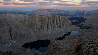
Mt. Muir was last California 14ers for me to complete. It's located in Whitey Zone and requires permit. We even got an overnight permit for Whitey for end of June, but due to fire it was canceled, so I have to do some improvisation. Instead of direct route I decided to start from Meysan Lakes and do loop with few bonus peaks.
| Foothills after recent fire |
| Meadow near Meson Lake |
| Between rock and ice |
| Mt Mallory |
| Bivi spot at 13,000 ft |
| Mt. Irvine |
| Sunset |
| Mt. Langley |
| Chimney |
| Mt. McAdie |
| Sky Blue Lake |
| Hitchcock Lakes |
| Mt. Muir |
| Mt. Whitney |