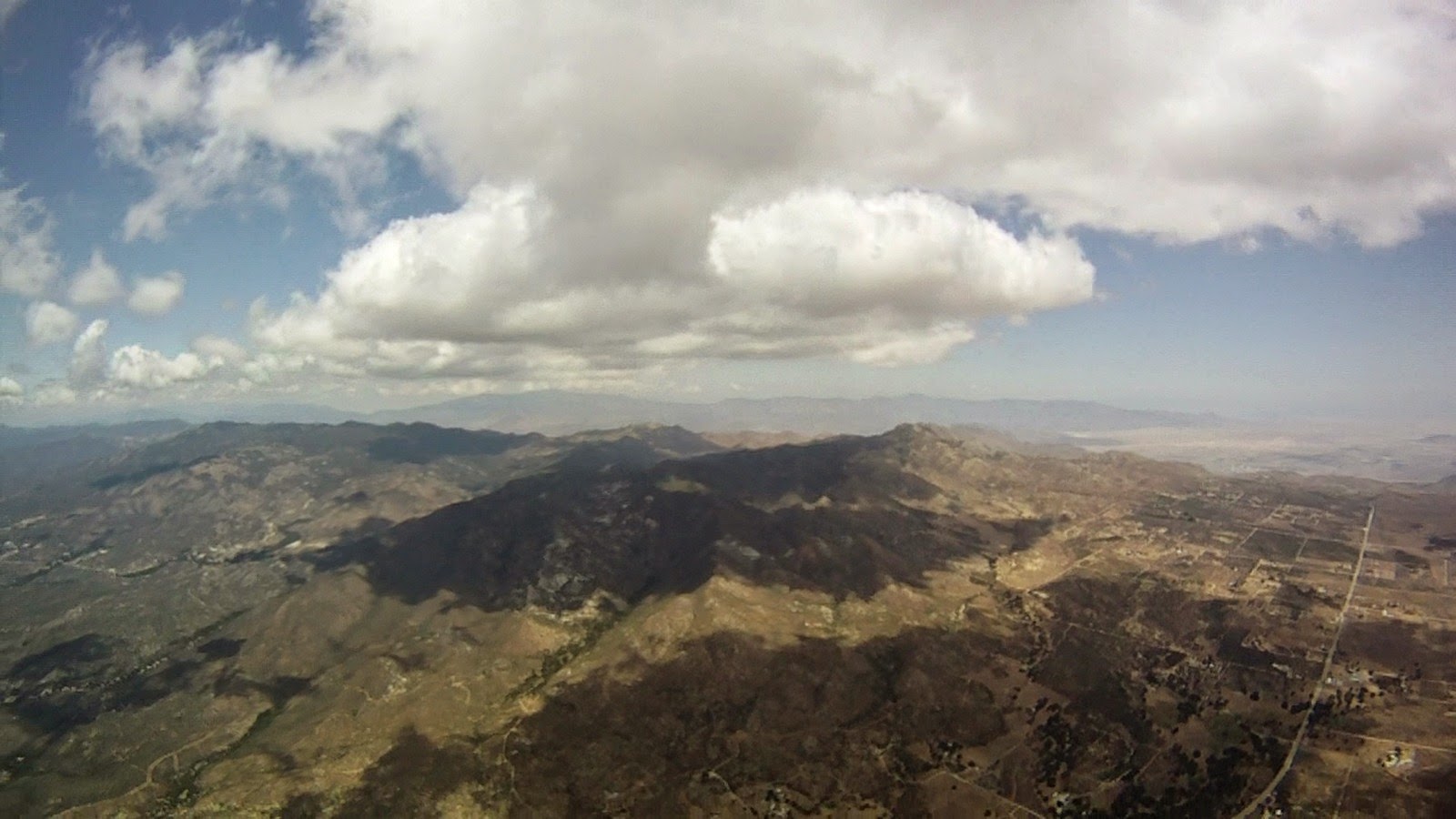
Slow day with relatevly low cloud base. Could not get high enough to fly over Weller creast. Going around did not quite work for me, there was rain and a lot of shade in the mountains and I was too low to find anything in the valley.
I still remember my first flight from Laguna 3 years ago, when I made mistake not to follow convergence, so I had obligation to come back and flew entire route. 1 week before the league forecast was great, but we was unable to get a team since it was Mother's day holiday. Surprisingly second weekend in a row we had another window to fly Laguna. You need light east wind, which is very rare event.
Palm Springs is a good goal for such flight, since it's shaded from Banning Pass wind, which normally picking up later in the day to dreadful 30+ mph. But to save 1:30 hours on retrieve time Aaron set goal just north east from Anza, so we don't need to drive down to Palm Springs and back. We also was thinking to tag Mt. San Jacinto outside of official task. Elapsed time, meaning you can start flying task as soon as you want was helpful too.
Mt. Laguna PG launch
I launched first at 11:16 followed by Len and Mark. We flew to start way-point at SPINES, but then Len took more straight line to Granite, while me and Mark spend more time trying to get higher before long transition.
Laguna launch from air
Flying with Len and Mark
I got pretty nasty 75% asymmetric collapse just near the spines, it came out ok with quite a surge.
We topped out at 7500 ft over Granite Mt. and went left toward VOLCAN to join convergence, which was already marked by nice fluffy clouds.
Getting into convergence near Volcan
I can see Len in front and Mark with Peter to my right with Aaron, Jason and Jerome following in a short distance behind. Ridge was working great and we all flew fast here, but split in the end of valley. Peter, Jerome and Aaron took left (west) route along San Felipe Rd., Mark right (east) toward Ranchita, Len and me center. Greg and Jason followed Mark shortly after.
Looking toward Ranchita from Volcan ridge
Crossing S22 highway, Ranchita on my right
Mark got low and landed, Jason and Greg turn left and was following me. I hoped to follow Len, but lost sight of him. Turned out he chose the best line in the middle of mountains. Warner Springs flats was not working, strong west wind was pushing through, Jerome and Peter landed way out in flats. Aaron was able to adjust his line toward the mountains quick enough and then 4 of us (me, Aaron, Jason and Greg) all meet in the same thermal.
Aaron on his blue Delta 2
Jason on orange Niviuk Artik
Greg left first taking a deep line even more east then Len. Jason apparently did not like strong wind and significant drift toward the mountains, he tried to push forward and eventually landed. I end up flying with Aaron, taking small climbs and fighting with west wind. Altitude was only 7500 ft, ridiculously low for crossing Hot Springs Mountains.
Aaron
Flying near Warner Springs
Slowly we was making our progress to the north. Russ had a slow start, he had a cravat, spent a lot of time fighting it, end up low and behind everyone, but keep flying and eventually catch up with us. Aaron missed one of the best thermals, which allow me and Russ to fly over the back to Chilhuahua valley, but recovered and was following us, however never catch up again.
Gliding to Chilhuahua valley
Flying with Russ
After we crossed Chilhuahua valley and climbed on the other side we had enough altitude to transition to Anza valley, which was completely shaded, regardless we can glide for 10 miles without a single turn maintaining our altitude.
Flying above Anza
We crossed Thomas Mountain range already in 4 km goal cylinder, but still need to tag last way point 5 miles north of us. Wind was strong from the west. Russ opted for lee side of Thomas Mt. and I crossed valley first to be on windward side. While climbing I spotted Len who tag the last waypoint and was heading for goal. Huge cloud was growing over San Jacinto and even on full speed bar, hurrying to waypoint I was going up quite fast. Just 1 km before waypoint's radius I decided to bail, cloud was below me and small exit to my left toward the sun start closing as well, I have to spiral down few times to lose altitude slowly pushing out from the monster cloud.
After flying from Marshall to Soboba and back last year I want to confirm that route works even without clouds and with moderate SW wind. Crossing I-10 between Redlands and Calimesa is far enough from Banning pass (with strong Venturi effect). Even if wind does pick up there is a plenty of space to land before the pass. After Redlands terrain is raising and line along this little ridge provides buoyant air, which is pushed from valley below by west wind.
Aaron was kind enough and agreed with the task, cloud base was good, but not epic, the best altitude I get was only 7K. It was great to see Len Szafaryn old time comp pilot decided to join us. We need PWC level pilots to learn from and I'm certainly missing flying with Eric, Josh, Dean and other top pilots. Flying his M6 Len was leading with Aaron and Peter close behind, then Mark, Me and Russ in the second gaggle. Our gaggle stop by at McKinley while lead gaggle skip it going directly to Harrison. While we was climbing Dmitry and Ziggy joined us as well and then both gaggles merged at Harrison.
Aaron decided to leave first, but flying more toward the Dam, not the route I want. Everyone else went directly toward Redlands airport and Brewery, climbing here and there, Aaron turn around and flew back to re-join the gaggle, but arrived much lower then everyone else. Lesson: don't get too far from the gaggle, especially when flying flats and route is not obvious. Len also could leave Harrison just by himself, with probably 10 minutes lead, but he choose to wait for a gaggle.
Our new lead gaggle was Len, Dmitry, Peter, me, Russ and Ziggy, but we split just before crossing I-10. I took more south line pushing upwind and Russ joined me, while everyone else opted for more direct line going south-east. Len and Dmitry did not get anything and pushed all the way to the ground landing near last way point (Fisherman's Retreat). Ziggy and Peter took a climb with strong drift toward the pass and become new lead gaggle of 2. We got separated with Russ and I took another climb, while he missed my thermal, pushed forward and landed too. Jeff, Tom and Paul took completely different line flying over Yucaipa.
There was interesting battle happening in front. Ziggy was now leading with Peter not far behind him, however Peter's line was better and Ziggy eventually stuck in the ugly looking canyon with power lines he could not cross and have to land. Peter made it first to Soboba with 2:42 time.
Crossing bad lands. Soboba visible ahead.
I spend too much time tanking up with altitude before crossing bad lands, so Peter was unreachable for me, I only hear him on radio reporting been on final glide to Soboba. I successfully crossed lad lands, but should probably take more direct line (faster and more buoyant based on Peter's track).
Banning pass, San Gorgonio (left), San Jacinto (right)
I had low save right over Gilman Springs Rd, climbing from 2500 ft to 5800 ft and then finishing second with 2:57 time. And two more pilots made goal. Jeff 3:06 and Tom 3:12, Ziggy was only 5 miles short and could easily win the day with one more thermal.
Peter, me, Jeff and Tom
Soboba Fly-in was in full action when we arrived. Cold beer was well deserved refreshment (Thanks Steve).
Finally I was able to link these 2 sites with a great flight. Usual 10:00 am meet up at LZ and we was ready to fly at 11:00, but conditions did not look optimal with some cycles coming from north and some from south. On the switch day I would like to have at least 20 min of consistent wind from south before launching, but this was not the case today. In fact poor HGs who choose to launch from Crestline that day was not able to launch because wind never switched. Despite north cycles I decided to launch at 12:22 (actually Tavis was 30 seconds ahead of me) with few other pilots including Russ, Eric and Paul. It was a good timing because north wind got stronger and other pilots including Ziggy stuck on launch for another 30 to 60 minutes. I climbed right to 8300 ft and start my journey westbound. Russ was first to cross, but stuck near Glen Helen and me, Eric and Tavis was able to catch up.
Eric crossing highway 15
Jonathan was rushing to Pine Mt., getting low there, flying all the way back to Cloud, recovering and making a second lap also catch up with us around that time. He choose deeper line toward Cucamonga peak and I joined him, while everyone else took more south line over the crest. Our line was better because wind was from the north and we stay on windward side, plus it was shorter. Then we all meet over Cucamonga except Jonathan who already crossed Mt. Baldy Rd. and had serious lead on us (does hang gliders fly faster or what?). We topped out around 11K and went over Ontario Peak. Beautiful scenery, especially snow on the peaks. I noticed blue Delta 2 flying deep line and was pretty sure that it's Ziggy flying with me. Only after we made it to Kagel I learned that it was Paul. Same glider, same color and the same flying style leaving thermals early and committing to deep lines without landable options.
Baldy Mt. (middle), Ontario (left)
There was north to north easy wind, so pushing upwind toward Baldy was out of the question. Next section was the most difficult part of the route, I know it very well from my previous Kagel to Marshall attempts. Surprisingly all of us made it though, but via different lines. Front points typically very windy and you can stuck there forever, so I and blue Delta 2 choose deep line, Eric and Tavis went to the front and Russ split the difference. We got a good climb with Paul after crossing highway 39, but still not enough altitude to glide directly to Monrovia on the back ridge and made slight detour toward Mt. Bliss.
Looking south toward Azusa
Monrovia Peak ahead
Now I was in the lead and pilots who took front line have to climb out from low altitudes and catch up. Time was 15:45 near Monrovia Peak and I start worrying about SW breeze. It could materialize any minute and that's pretty much end of the game. I pushed bar and stop taking thermals with few exceptions where they was absolutely necessary.
Mt. Wilson
As it turned out taking climb near Big T to 7.6K was important for making goal. It's near Big T where I first encounter SW breeze, strong and laminar air blocking thermal activity and slowing down my progress. I can't even clear Trash and have to go around and ridge soar to the top. But finally I flew by Kagel launch:
Kagel
Jonathan was first to complete the route landing at 16:30 after tagging West Towers as well, I was second at 17:30, then Tavis 5 minutes later and finally Paul. Russ was only 1 mile short from LZ, he landed in front of Trash and hiked to LZ. Eric landed in Big Tujunga Canyon. I also met Greg Kendall (HG) near Monrovia Peak who flew opposite direction from Kagel to Marshall.
Last time I flew Elsinore was 7 years ago in September 2007. Weekend forecast for Marshall was great and there was also supposed to be fly-in at Marshall, so my choice in the middle of the week was obvious. However, Jonathan suggested Elsinore. Advantages was that it will not OD and you can fly with any altitude even with 6K you may have a chance, where at Crestline you need at least 8K to make it OTB (over the back), plus there could be OD in the mountains and desert. I hesitate for a while, I don't like Elsinore because you can bomb out there very easy, just slightly wrong timing and you land, no matter what you try to do. And that's exactly what happened with Jonathan. Jeff, Kia, Ziggy, Russ, Mike Everyday and few HG was flying that day too, Ziggy's wife Linda volunteered to drive retrieve. Thank you Linda!
We agreed to meet at LZ at 10:15, but Ziggy was late by half an hour, so we got to launch around 11:00. Good cycles and few pilots was already in the air. I launched at 11:23. Only Jeff who launched early was able to climb high right away and flew north, but he decided to wait for us. Everyone else have to spend some time near launch with Kia and Jonathan landed on primary LZ. After we got to 4500 ft we start flying north and was getting better climbs, eventually topping out at 7600 ft. That was decision point. My plan was to fly straight line with 4 control points I put to my GPS to make sure I avoid all air spaces. Going further NW was off my route, so I stay in zero sink and start drifting north, took another small climb and cross highway 15.
Looking back at Elsinore Lake
All other pilots was keep flying NW toward Santiago Peak, excited by good climbs to 9K+. There are small hills on the other side of 15 and landable valley after, which I had on glide.
Crossing highway 15
My altitude dropped back to 4500 ft after crossing, but I found a good climb just before the valley, which took me all the way to 9600 ft and near the top nice looking clouds start forming. That altitude was enough to glide to Box Springs Mountain Park.
Lake Mathews
I did not encounter any lift of sink on glide, just stable, laminar air. Wind was south at altitude and SW down low. I pick my LZ near small hill and went for some ridge soaring session, which worked. I was able to drift north, but could not climb out. Eventually my altitude dropped to 300 ft AGL and I was on my landing approach when helper thermal knock on my wing's sail. Yahoo!!! Back in the game. The problem was that west wind pushed me 1.5 miles east from my control waypoint and now I had San Bernardino Class D ahead of me. Good news was that top of airspace was 3200 ft and I decided to adjust my plan and try to fly over it. After first climb I got only to 3500 ft, which was not enough. Second climb to 5000 ft gave me some time to find another thermal or push west to avoid airspace. Luckily I found another climb to 6200 ft drifting to the north.
Intersection of 215 and 10
San Bernardino airport
On glide to the mountains
At that point I need one more climb to make it to the mountains, which was easy to find. But task was not over yet, since I came to mountains SE from Arrowhead peak and need to fly 5 miles back to Marshall. Head wind was strong, climbs was rowdy, but it was my home area, I know it very well and it was just matter of time to push back. No PG over Marshall during fly-in with parking lot full of cars is not a good sign, and several, almost parked, Falcons (low pref. HG) did not add inspiration either. My ground speed dropped to 5 mph, but with speed bar I was able to fly out front and (guess it) can't land! because lift was everywhere. I try spirals, wing overs, try to search for sink. After half an hour struggle I was finally able to land. Jeff was able to complete the same flight also, but he took a serious detour flying around March AFB and San Bernardino Class D from the east. Thanks for the ride back to Elsinore Jeff.
Jeff landing at Andy Jackson
Bill Soderquist (HG) flew from Elsinore all the way to Cajon Mountain past Marshall via Yucaipa and all the way back to Elsinore.
I think all of the pilots familiar with XC flying when driving on highway 210 (or 10) along San Gabriel mountain range was at least thinking about Kagel to Marshall flight or vice versa. The best time for high altitude flights on the front range usually in the spring when Santa Ana (north) wind switch to south and there is no inversion around or later in the August or September after monsoonal moister and summer hit generates some thunderstorm activity.
Earlier this week there was very strong Santa Ana, wind was gusting up to 70 mph and Friday supposed to be a switch day. But gusty wind also resulted in the Etiwanda fire near Rancho Cucamonga and corresponding TFR (temporary flight restriction), which was exactly on the course line and put the end on Kagel to Marshall flight plan. Alternative option was to fly OTB (over the back) and follow highway 15 with SW wind. I did similar flight 2 years ago, but at that time I did not plan it, just follow HG's which means late start as well as not optimal route since I had no idea where I'm going. Now I have all time I need to prepare.
Aaron and Tavis agreed to join and Katie volunteer to drive. We meet at 9:45 at Kagel LZ and was on launch at 11:00. Good strong cycles, birds climbing easily all indicators pointed to the good day. I launched first at 11:27 and climbed right away to 6.5K, Aaron and Tavis launched shortly after and we all headed to BigT. I expected some SE wind, which means you arriving to lee at BigT, but it was not too bad. At BigT we spend some time making sure day is developed enough.
Climbing behind BigT. Mt. Lukens on the right
After few climbs we got to 8.5K (12:35 pm) and start our transition toward Mt. Gleason, but that altitude was not enough. We have to stop near Iron Mt. and search for one more climb, we spread around we found good enough thermal drifting in the right direction, eventually arriving to Gleason at 7.5K (1:10 pm). This is prominent peak and the best place to tank up. I was worry that we may encounter north wind here, but fortunately it was south already. We climbed to 11.5K and continue along the ridge. Aaron and Tavis stopped to check out some light staff, but I continue to nice looking SW facing mountain behind Angeles Forest Hwy and get right into +5 m/s climbing to 12.7K. Tavis was next and got into the same thermal, but Aaron missed that one and have to scratch low for awhile. Drift was from the NW, but not too strong. From that altitude we can easily cut across no mans land toward Juniper Hills.
Crossing San Gabriel Mountains
Tavis had slightly less altitude and decided to search on west side, while I pushed forward along ridge crest and finally found next good thermal, which took me to 14.4K with drift mostly from the west (good). Now I was all by myself. Just before Wrightwood I left mountains and went for the flats (3:00 pm).
Wrighwood ski resort and Mt. Baldy (with snow)
To my disappointment wind was from the NNW and my progress was very slow. Near Phelan I run into convergence and had my best thermal of the day to 15.1K. In the Victorville drift was from the west down low and from the north up high (4:30 pm), so I need to adjust my strategy. In the main time Aaron caught up with Tavis and they both decided to land near Spring Valley Lake in Victorville. I continue north along a dirt road (Stoddard Wells Rd.) periodically reporting my status to the crew. Thermals was getting lighter and wind was from west, while I need to fly north, altitude was dropping more and more. I was hopeless to make it to Barstow hopping from one hill to another, ready to land on dirt road at any time. Then I saw small village and paved road (Hwy 247) just to my right, which was down wind and at the same time found light thermal. Now I could cut the corner with my LZ on the nice green field few miles east of Daggett.
Daggett and Hwy 40
I landed at 6:47 pm. My friends was watching my progress on SPOT page and was there before I even unhook harness.
Forecast was for 10K+ cloud base, light SE wind for front (San Gabriel Mountains) range and NNE wind for back range changing to SW (and NNW) later in the day. When its east wind Marshall is more preferable, but since I did not have a driver for Marshall and my wife Karina volunteered to drive if I go to Kagel I choose Kagel. Got a ride on 10 am track, we were packed like sardines in the can, but starting early was very important. In fact cycles on launch was too strong and I was concerned I could not even launch, but wind during lulls was light and lulls last for few minutes, so I did launched successfully at 11:46. No problem with penetration climbed to 5.5K and went for Big T. SE wind there was much stronger then predicted in forecast. I could not go east even on full speed bar, so I turn around and fly back to west towers. I got to 8.2K there and consider jumping west to Oat Mt. or north-west to Santa Clarita.
Flying high over Sylmar
By that time most of Sylmar XC crew was in the air over Big T. discussing plans where to go. Jonathan went east on the front range and the rest of pilots jump to the back ridge aiming to fly OTB (over the back) via Mount Gleason. I was dreaming to try this route for a long time, so there was no question any more where to go. Ron reported 11K+ on the back ridge with other HG pilots joining him. I was last to commit and even though I had 10.4K it’s was one of the scariest move in my PG career. There is a 10 miles stretch with no place to land from Big Tujunga canyon until you get to Gleason. It took only 20 minutes to cover this distance and I arrived at 7.5K (1.6K AGL) over the last ridge near Gleason. As expected there was a strong thermal out there and I took it all the way to 13.5K, but higher I was getting the stronger north wind become, so I have to leave thermal and fly upwind toward the highway 14.
Flying over San Gabriel Mountains
Plenty of LZ after that point, but with north wind my progress to the east was slow. Most of HG landed at Crystal airport, but when I got there they was gone already, so I landed at 6:25 near highway 138 and 18 intersection for easy retrieve.
Good forecast for 10K+ with east wind all day convinced me to take a day off. Usual suspects in our team, Rebar Dan, Jonathan and our driver Greg. Launched at 11:42 into a strong cycle, went straight up, barely penetrating forward. Go to Pine Mt. and climb to 9.4K right away
Flying high over Pine Mt.
10.9K near Cajon pass, easy crossing
Flying across Cajon pass
Jonathan passed me on the other side of the pass, taking more north route. I prefer to stay over small ridge along Long Pine Creek Rd. There is good trigger point before Wrightwood the only problem it's always turbulent and this time was not an exception. There was a shear line on certain altitude and wing was all over the place, luckily no collapses. After Wrightwood meet with Dan, he was in the same thermal, but lower. 11.3K altitude motivated me to start flying faster, so I did not top out in each thermal (mistake #1). Then I saw Jonathan over Devils Punchbowl Park climbing well and rushed there, but could not connect with his thermal. Get some altitude after low save, but was not sure I can jump safely to the back range and since terrain is rising I would arrive there low.
Devils Punchbowl Park
Instead I keep going over small ridge hoping to get another thermal (mistake #2), which put me to the ground early. Right decision was to stay in thermal and slowly drift with it to the back range.
Landing near Valyermo
When I was done packing my gear I saw clouds start popping over the peaks and sure enough convergence line was bearing toward the back range exactly where I hit sink and lost most of my altitude. Hitch a ride to highway 138 where Greg picked me up and we start chasing Dan & Jonathan. Dan landed between Lake Elizabeth and Lake Hughes, 72 miles out. Jonathan made 88 miles, but landed behind a gate, so it took us quite some time to get him.
Gate to Tehachapi afterbay
When we was going to the launch I had a conversion with another PG pilot and say that if he want to fly XC he need to be ready for getting back home at midnight and that’s exactly when I got home that day.