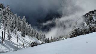
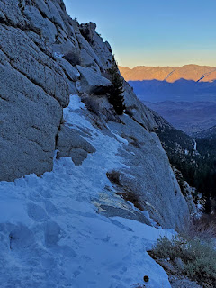
Initial plan was to hike Mt. Baldy, but snowy and icy road conditions was too much for my Prius, even with chains it could not make switchbacks, so we retreated to Ice house canyon. Easy going to saddle. There was probably 10 or so people in front of us, but after saddle most of them turned around. We had a great hopes for 2 folks with snowshoes, but after 100 feet they was confused and scared and went back as well, so it was my turn to lead. Very enjoyable exercise sometimes falling chest deep into the snow. Poor Fedor was struggling even to follow, so speed was very slow. We made it to Cucamonga / Bighorn saddle before turning around.
Sunday, January 24, 2021
Saturday, January 16, 2021
Mt. Whitney
Mountains does not forgive mistakes, even little ones. Our annual Whitney trip did not go well for me this time. It was nice to get out, but no summit just because of 3 AAA batteries. We get a few hours nap at trail head, actually somewhere between lower and upper gates. My flashlight died after 1 hour of hiking, but going up was not that bad.
| Sunrise near Upper Boy scouts lakes |
| Iceberg Lake |
| Mountaineering chute |
| My high point, ~13000 |
Saturday, January 9, 2021
Bridge To Nowhere hike
Easy 10 miles out and return hike to abandoned bridge on a washed-away road in the San Gabriel Mountains that spans across the East Fork of the San Gabriel River. Relatively flat with multiple river crossing. Took us 2:30 one way.
| Bridge to Nowhere |
Some river crossing did not go as well as other. Ha ha.
Saturday, January 2, 2021
Styx Canyon - Death Valley
![]() |
| Styx Canyon |
Saturday, November 14, 2020
Skyline
I have been organizing annual Skyline hike for the last 10 years, which was a great success with different groups of friends connecting together and having a good time. On some years we also hike it in the spring to see blooming flowers. This year first storm was hitting SoCal just 1 week before our hike, so we could see a full contrast from 100F in the valley to snow on the top.
![]() |
| 2020 Skyline hikers |
![]() |
| Snow at the top |
![]() |
| Temperature in the valley |
Saturday, August 8, 2020
Palisade Traverse
According to the Internet:
Palisade Traverse is one of the best alpine climbs in the Sierra Nevada and one of the very best ridge traverses on the planet. This route takes in five 14,000 foot peaks and features amazing views and exhilarating climbing.
It includes following peaks:
- Thunderbolt (14,009 ft)
- Starlight (14,226 ft)
- North Palisade (14,248 ft)
- Polemonium (14,080 ft)
- Sill (14,153 ft)
Haytham joined me on this adventure and was already familiar with first 2 peaks and route between them, which helped a lot. We decided to go from the west side and camped near Bishop pass on the first night. We started from Bishop pass around 3:00 AM, reached Thunderbolt pass by 5:30 AM, and went up the Southwest Chute #1.
![]() |
| Thunderbolt Southwest Chute #1 |
We get to Thunderbolt around 8:30 AM and was lucky to find another group there who allowed us to use their rope. Summit block is unprotected 5.9 boulder problem and I was not very excited to leaded it unless I have to.
![]() |
| Starlight from Thunderbolt |
Route to Starlight involved some not very obvious detour to the right, which saved us a lot of time. Another group went in the middle of the ridge and have to rappel for awhile. They did not even get to the saddle by the time we were on Starlight already. After the saddle you have to go even more right and around to avoid class 5 climbing.
![]() |
| Looking west |
![]() |
| Down climb to Thunderbolt-Starlight saddle |
We got to Starlight around 11:00 AM and Haytham lead the 5.4 summit block. I was doing ok, but start feeling altitude somewhere around this point.
![]() |
| View from Starlight |
![]() |
| Looking west from the ridge |
By 2:00 PM we reached North Palisade, and my altitude sickness progress to the point I can't move very fast, so we decided to call it a day and descent from U-notch (to the west of course). From the North Pal. we missed the correct path, which supposed to go right (west) and end up on pretty bad rappel path with sketchy anchors, falling rocks, etc., so I would not recommend going that way.
![]() |
| Looking SW from North Pal. |
![]() |
| Looking west from U-notch |
![]() |
| Sunset at 8:00 PM |
Here is what can be done better next time:
- Better acclimatization. For 1 peak it does not really matter, but for traverse where you spend a lot of time above 14K it's crucial.
- Start should be as close to the route as possible. We wasted probably 4 hours hiking in and out. Camping at Thunderbolt pass (or on the east side) would be much better.
- 3 days minimum. Trying to squeeze it into 2 days was a mistake.
Friday, July 17, 2020
Mt. Abbot (attempt)
Trail to Mt. Abbot (13,711 ft) starts from Little Lakes Valley Trailhead (Rock Creek) conveniently located at 10,200 ft. Only Fedor joined me this time. We slept at trailhead and started early in the morning hoping to tag Mt. Abbot via North East Couloir and camp either near Mills lake or Treasure Lakes.
![]() |
| Mt. Abbot map |
![]() |
| Ruby Lake |
![]() |
| Mills Lake (top one) |
![]() |
| North East Couloir of Mt. Abbot (left) |
We was able to get to the beginning of couloir (~13,000 ft) when 3 contributing factors helped me to abort the mission: Fedor start feeling altitude with light headache, storm was forming to the north of us and it was almost 2:00 PM, kind of late. We took few pictures and continue to Treasure Lakes.
![]() |
| Treasure Peak |
![]() |
| Fishing at Treasure Lake |
Treasure Lakes are at 11,200 ft. After eating soup and drinking hot tea Fedor feel much better and went fishing, but did not catch anything, we need to practice more.
![]() |
| Our campsite |
![]() |
| Treasure Lake |
![]() |
| Little Lake Valley |